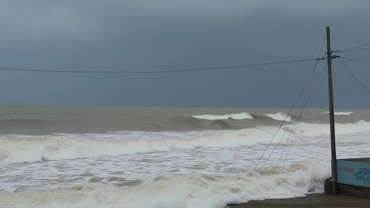
By the time the sun set on October 27, 2025, the Bay of Bengal had turned into a churning cauldron. Cyclone Montha — named for the Thai word for "fragrant flower" — had surged from a depression to a severe cyclonic storm, its eye now locked on a stretch of coastline between Machilipatnam and Kalingapatnam, near Kakinada in Andhra Pradesh. The India Meteorological Department (IMD) warned of wind speeds hitting 100 kmph, with gusts up to 110 kmph. Landfall was expected between 7 p.m. and midnight. And the countdown had already begun.
Red Alert in Andhra, Orange in Odisha — and the Rain Already Started
The IMD issued a red alert for Andhra Pradesh, the highest warning level, and orange alerts for Odisha, Karnataka, Tamil Nadu, and Kerala. But here’s the twist: the rain had already started. In southern Odisha, including Bhubaneswar, residents woke up to drumming rain on rooftops. "It’s not just coming," said Pujari, a state government official. "It’s here. And it’s getting worse." By 2:30 a.m. on October 27, the storm’s center was 450 km south-southeast of Kakinada, moving northwest at 15 kmph. By the next day, it was expected to slow slightly — and intensify. The IMD warned of "extremely heavy" rainfall in isolated pockets of coastal Andhra Pradesh, Yanam, and even Telangana. In Chennai, the Greater Chennai Corporation had mobilized 22,000 personnel to 160 flood-prone zones. Schools in Chennai, Tiruvallur, and Chengalpet were shut. A Delhi-Vizag IndiGo flight was diverted to Bhubaneswar. Two others — Vizag to Bengaluru and Vijayawada to Vizag — were outright cancelled.Shelters, Sandbags, and Stolen Sleep
In Andhra Pradesh, the state government had pre-positioned over 50,000 tarpaulins, ropes, sandbags, and plastic sheets — not just for homes, but to shield crops still clinging to the fields. Beaches were closed. Fishing boats, once the lifeblood of coastal villages, were hauled ashore. "Most fishermen have already returned," said the State Relief Commissioner of Odisha. "The sea is no longer an option." In Gajapati, a hilly district in southern Odisha, 139 landslide-prone locations were flagged. Authorities evacuated families from 47 of them. Government employees across nine districts had their leave cancelled until October 30. Schools and anganwadi centers shut. It wasn’t just precaution — it was survival. Even across the border, Ganjam district in Odisha took in over 100 fishermen from Andhra Pradesh. "They’re safe for now," said a local relief worker. "They’ll go home when the sky lets up."
Chhattisgarh, Bihar, and the Ripple Effect
The storm’s reach wasn’t confined to the coast. Chhattisgarh was bracing for "extremely heavy" rainfall on October 28. West Bengal, Sikkim, Jharkhand, and Bihar were warned of light to moderate rain between October 29 and 31 — with isolated heavy downpours and lightning. In Visakhapatnam, visibility dropped so low on October 27 that even the airport shut down temporarily. The city, usually a bustling hub, felt eerily quiet. "This isn’t just a coastal problem," said Senthamarai Kannan, director of the Andhra Pradesh Regional Meteorological Centre. "The system’s energy is spreading inland. The rain doesn’t stop at the shoreline."What’s Next? The Long Road After the Storm
Even after landfall, the danger won’t vanish. The IMD predicts the cyclone will weaken slowly, lingering as a deep depression over northern Andhra and southern Odisha through October 30. That means flooding, power outages, and damaged roads will be the new normal. Emergency teams are on standby — but roads may be washed out. Phones may go dead. Supplies may get stuck. The real test comes after the winds die down. Will the 50,000 tarpaulins be enough? Will the shelters have clean water? Will the fishermen get back to their nets? And what about the crops — the rice, the pulses, the chillies — already soaked by days of pre-cyclone rain? "We’ve done what we can," said an Andhra Pradesh district collector, speaking off-record. "Now it’s up to the sky."
Background: Why This Cyclone Is Different
Cyclone Montha is the third major storm to threaten India’s east coast this year — after Cyclone Biparjoy in June and Cyclone Tej in August. But unlike those, which stayed offshore, Montha is aiming straight for the population-dense corridor between Kakinada and Visakhapatnam. That’s home to over 12 million people. Historically, cyclones forming in the Bay of Bengal in late October tend to be stronger — the ocean is still warm from summer, and wind shear is low. This one, experts say, is textbook for the season. The IMD’s forecast accuracy has improved dramatically since 2019, when Cyclone Fani caught many off guard. This time, the warnings came early. But early warnings don’t stop the water.Frequently Asked Questions
How are authorities ensuring safety for fishermen and coastal communities?
Over 100,000 fishermen across Andhra Pradesh and Odisha were ordered to return to shore by October 27. All ports hoisted Distant Cautionary Signal No-I, and shelters were opened in districts like Ganjam. The government distributed emergency kits with food, water, and flashlights. Over 13,000 people were moved to 217 designated shelters — many in schools and community halls reinforced to withstand high winds.
Why is Gajapati district especially vulnerable?
Gajapati’s hilly terrain, combined with loose soil and heavy rainfall, makes it prone to landslides. The state identified 139 high-risk zones, many near villages with limited road access. In 2022, a landslide in the same district killed 17 people. This year, evacuation teams are using drones to reach remote areas and have pre-positioned rescue boats and ropes at key points.
What impact will this have on food supplies and agriculture?
Coastal Andhra and southern Odisha produce nearly 30% of India’s rice and millet during the Kharif season. Over 1.2 million acres of standing crops are at risk. The 50,000 tarpaulins deployed are meant to protect harvests, but if flooding lasts more than 48 hours, most will be lost. The National Disaster Response Force has already coordinated with the Food Corporation of India to pre-position grain stocks in unaffected districts.
Why were flights cancelled and diverted?
Poor visibility due to heavy rain and low clouds forced the closure of Visakhapatnam Airport on October 27. A Delhi-Vizag IndiGo flight was diverted to Bhubaneswar, while two other flights — Vizag to Bengaluru and Vijayawada to Vizag — were cancelled. Air traffic control in Chennai and Hyderabad also delayed departures, fearing turbulence and wind shear. Flights are expected to resume only after October 30, once the system moves inland.
How does Cyclone Montha compare to past storms in the region?
Montha’s peak winds (90–110 kmph) place it just below Category 1 hurricane strength. It’s weaker than 2019’s Cyclone Fani (200 kmph) but stronger than 2023’s Cyclone Michaung. What’s alarming is its trajectory — it’s targeting a densely populated stretch that hasn’t seen a direct hit since 2016. The IMD’s early warnings, however, mean this one may cause less loss of life than previous storms.
What’s the timeline for recovery?
Power restoration could take 7–10 days in flooded areas. Roads in Odisha’s coastal belt may be impassable for weeks. The state governments have pre-approved ₹400 crore for immediate relief. Long-term recovery — rebuilding homes, replanting crops, restoring fisheries — will likely span six to nine months. The National Disaster Management Authority has already begun mobilizing engineers and agricultural experts to begin damage assessments by October 31.
Written by Zander Lockhart
View all posts by: Zander Lockhart